Your Cart is Empty

5 MUST VISIT 4x4 LOCATIONS
During our travels, we've crossed a lot hot spots off of the bucket list. Must visit 4WD tracks & destinations, driving on the beach til the sun sets, getting bogged in the sand dunes of the Simpson Desert and climbing stunning mountains. We've put together a list of just a few of the top hits, based around the Queensland area. Have a read, and plan your next trip!
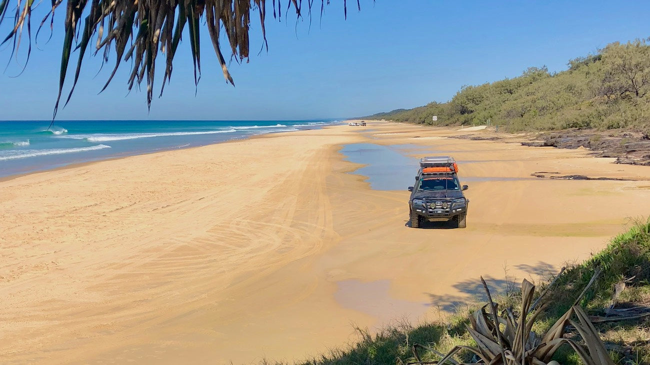
1. Kgari (Fraser Island)
One of our all time favourites, and just three hours drive north of Brisbane, Kgari (pronounced “gurrie”) Fraser Island, is part of the Great Sandy NP and it’s not World Heritage listed for nothing! Its original inhabitants, the Badtjala people, called it Kgari meaning paradise, and after you experience its many delights for yourself you will no doubt agree. The world’s largest sand island features seemingly endless white sandy beaches (that you can drive on and camp behind), lush tall rainforests, magnificent crystal clear freshwater lakes and streams, vast paperbark and sedge swamps, huge sand dunes, rugged rocky headlands and great 4WD’ing, camping and fishing. The easiest access is via the Manta Ray barges that make a short crossing to the island’s southern end from Inskip Point, a short drive north of Rainbow Beach.
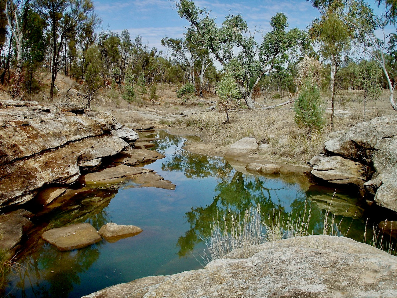
2. Mount Moffat
Much less well-known than its famous neighbour, Carnarvon Gorge, the Mount Moffatt section of the Carnarvon NP in Central Queensland’s sandstone belt has a remote feel, amazing scenery and an interesting history. The park, about 600 km north west of Brisbane features unique sandstone outcrops, caves, pillars and arches; Queensland’s highest plateau and some of our tallest trees, (giant swamp mahogany at the head of Carnarvon Creek); important rock art sites, and the hideout cave of a couple of notorious local bushrangers, the infamous Kenniff brothers.
Prominent sandstone features such as Lot’s Wife, Marlong Arch, The Chimneys, The Looking Glass, The Tombs, Kookaburra Cave and Cathedral Rock are scattered throughout the park and make for interesting walks and photographic subjects along the scenic Mount Moffatt circuit drive. There are four basic camping areas (with toilets) scattered throughout the park, while the track to the top of the Consuelo Tableland (the roof of Queensland) is only accessible by high clearance 4WD’s in dry weather.
3. Blencoe Falls
The smash hit US TV series Survivor II: The Australian Outback focused the attention of the world on this ruggedly spectacular part of North Queensland; the Wet Tropics World Heritage Area. The towering waterfalls, sandy riverbanks, sheer granite cliffs and crystal-clear streams that looked so fabulous on the small screen are far better in real life and if you’d like to experience them for yourself, you could do worse than to set up camp at the spectacular and imposing Blencoe Falls, in the beautiful Girringun National Park, on the Great Dividing Range between Townsville and Cairns. The sparkling water of Blencoe Creek tumbles 90 metres, then 230 metres to the bottom of the gorge before joining the mighty Herbert River further downstream. Above the falls, Blencoe Creek is great for swimming while nearby a couple of rough 4WD tracks lead off to vantage points above or below the stunning cascades.
It is possible to hike down from one of the lookouts to the confluence of Blencoe Creek and the Herbert River, but the rugged 1.5 km foot track drops 300 metres down a steep mountain spur and isn’t well marked, so only fit and experienced bushwalkers should attempt it. The drive up from the small hamlet of Kennedy (on the Bruce Highway 10km north of Cardwell) on the Kirrama Range Road (closed in the Wet Season) meanders beneath a canopy of lush tropical rainforest and begins a gradual, twisting ascent of the Cardwell Range. Along the way, you’ll pass a couple of lookouts that afford fantastic views over Hinchinbrook Island and the smaller islands of Rockingham Bay. Above the falls the camping areas along the creek feature open woodland campsites for large groups, as well as small sheltered sites.
Click for more Information on Blencoe Falls
4. Welford NP
If the Simpson Desert seems just a tad too far to head for an Easter break, then the 124000-hectare former cattle station, Welford NP, in Queensland’s Central West makes a great alternative ‘arid lands’ destination. This land of contrasts features red sand dunes clothed in golden-green spinifex and white-barked ghost gums; the banks of the muddy brown channels of Barcoo River lined with majestic river red gums, Mitchell grass plains, arid mulga woodlands, crusty claypans and stony escarpments and gullies. This beautiful park is an important refuge for rare wildlife such as the yellow-footed rock-wallaby and the mulga parrot. You might also spot red and grey kangaroos and wallaroos, Major Mitchell cockatoos, red-winged parrots, white-plumed honeyeaters, mallee ringnecks, pelicans, brolgas, black swans, cormorants, whistling kites and emus.
There are also reminders of the land’s traditional owners in the form of wells and stone arrangements, and of early European settlers in the stockyards and the National Trust-listed 1882 rammed-earth homestead that now serves as the Park Ranger base. Welford has three self-guided scenic 4WDrives; Desert, River and Mulga that let you explore the park’s diverse environs. Sawyers Lookout on the Mulga Drive is the place to watch the sunset while Little Boomerang Waterhole Camping Area (with pit toilet) overlooks a large permanent waterhole on the Barcoo that’s ideal for canoeing and kayaking.

5. Munga-Thirri National Park (formerly Simpson Desert National Park)
I often hear “It’s a long way to go to look at a sandpit! Why would you go there?”
My reply is “Just go, and I guarantee that you’ll be itching to go back.” The Simpson Desert (named after Alfred Simpson of washing machine fame, and a former president of the Royal Geographical Society of South Australia) is the worlds’ largest parallel sand dune desert. Covering 176000 km2, this vast expanse of sand, in colours from deep red in the north to pale yellow and white in the south, straddles the border of Queensland, South Australia and the Northern Territory and is a destination that will lure you back time and again to explore its remote and desolate beauty. There are a few routes that cross the desert from east to west (the QAA & French Line, the Rig Road and the Madigan Line (our favourite) as well as a couple of less used tracks that run north to south (Hay River and Colson tracks).
The ‘Simmo’ will stir your soul with its absolute silence, big blue sky, amazing landscapes, patterns and vistas, and its clear starry nights. Out in the middle, the sense of remoteness and isolation is profound, and you seriously need to be properly prepared, but if tackling 1100 sand dunes (some much more challenging than the rest) sounds like an adventure that you’d relish, then load up your 4WD, head to Birdsville (if coming from the East) or Mount Dare (from the West), fill your tanks to the brim with fuel and water, and get ready to fall in love with Australia’s sandy red heart.

For more great trip tips, join the MAXTRAX Army on Facebook!
x